Geolocate

Tonga topographic map

Click on the map to display elevation.

About this map

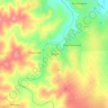
Name: Tonga topographic map, elevation, terrain.

Location: Tonga, Nkomazi, Ehlanzeni District Municipality, Mpumalanga, 1357, South Africa (-25.72958 31.74674 -25.64958 31.82674)

Average elevation: 768 ft

Minimum elevation: 617 ft

Maximum elevation: 912 ft

Other topographic maps

Click on a map to view its topography, its elevation and its terrain.

Gear up for your next adventure:

🎁Geography Themed Gifts - Unique gift ideas for map lovers and geography enthusiasts
🗃️Trail First Aid Kit - Essential kit for outdoor injuries and emergencies
🏕️Family Camping Gear - Essentials for group camping trips
🗺️NatGeo Topo Maps - High-quality waterproof printed topographic maps of US Parks
🥩Freeze-Dried Meals - Nutritious and lightweight food for remote expeditions

As an Amazon Associate, this site earns from qualifying purchases at no extra cost to you.