
Make a donation
Gear up for your next adventure:
As an Amazon Associate, this site earns from qualifying purchases at no extra cost to you.
Kalol topographic map
Click on the map to display elevation.
Make a donation
Gear up for your next adventure:
As an Amazon Associate, this site earns from qualifying purchases at no extra cost to you.
Kalol
Kalol has an average elevation of 81 metres (266 feet). SH41 Highway passes through Kalol. The city sits on the banks of the Sabarmati River, in North-Central-East Gujarat.
Make a donation
Gear up for your next adventure:
As an Amazon Associate, this site earns from qualifying purchases at no extra cost to you.
About this map
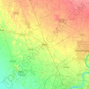
Name: Kalol topographic map, elevation, terrain.
Location: Kalol, Kalol Taluka, Gandhinagar, Gujarat, 382700, India (23.08522 72.33662 23.40522 72.65662)
Average elevation: 230 ft
Minimum elevation: 135 ft
Maximum elevation: 338 ft
Make a donation
Gear up for your next adventure:
As an Amazon Associate, this site earns from qualifying purchases at no extra cost to you.