
Durgam Cheruvu Secret Lake Park topographic map
Interactive map
Click on the map to display elevation.
About this map
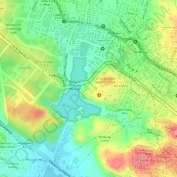
Name: Durgam Cheruvu Secret Lake Park topographic map, elevation, terrain.
Average elevation: 1,900 ft
Minimum elevation: 1,772 ft
Maximum elevation: 2,064 ft
Other topographic maps
Click on a map to view its topography, its elevation and its terrain.
Gopanpally Tank
India > Telangana > Serilingampalle mandal > Hyderabad
Gopanpally Tank, Ward 105 Gachibowli, Greater Hyderabad Municipal Corporation West Zone, Hyderabad, Serilingampalle mandal, Ranga Reddy District, Telangana, India
Average elevation: 1,893 ft
Durgam Cheruvu
India > Telangana > Serilingampalle mandal > Hyderabad
Durgam Cheruvu, Durgam Cheruvu Road, Madhapur, Ward 104 Kondapur, Greater Hyderabad Municipal Corporation West Zone, Hyderabad, Serilingampalle mandal, Ranga Reddy District, Telangana, 996544, India
Average elevation: 1,893 ft
Patel Cheruvu
India > Telangana > Serilingampalle mandal > Hyderabad
Patel Cheruvu, Ward 108 Miyapur, Hyderabad, Serilingampalle mandal, Rangareddy, Telangana, India
Average elevation: 1,893 ft