
Thank you for supporting this site ❤️
Make a donation
Make a donation
Gear up for your next adventure:
As an Amazon Associate, this site earns from qualifying purchases at no extra cost to you.
Choquenaira topographic map
Click on the map to display elevation.
Thank you for supporting this site ❤️
Make a donation
Make a donation
Gear up for your next adventure:
As an Amazon Associate, this site earns from qualifying purchases at no extra cost to you.
About this map
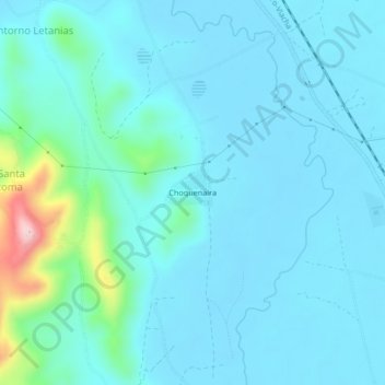
Name: Choquenaira topographic map, elevation, terrain.
Location: Choquenaira, Viacha, Ingavi, La Paz, Bolivia (-16.71444 -68.30667 -16.67444 -68.26667)
Average elevation: 12,753 ft
Minimum elevation: 12,638 ft
Maximum elevation: 13,524 ft
Thank you for supporting this site ❤️
Make a donation
Make a donation
Gear up for your next adventure:
As an Amazon Associate, this site earns from qualifying purchases at no extra cost to you.
Other topographic maps
Click on a map to view its topography, its elevation and its terrain.