
Make a donation
Gear up for your next adventure:
As an Amazon Associate, this site earns from qualifying purchases at no extra cost to you.
Madhugiri topographic map
Click on the map to display elevation.
Make a donation
Gear up for your next adventure:
As an Amazon Associate, this site earns from qualifying purchases at no extra cost to you.
Madhugiri
Madhugiri is located at 13°40′N 77°13′E / 13.66°N 77.21°E / 13.66; 77.21. It has an average elevation of 787 metres (2582 feet).
Make a donation
Gear up for your next adventure:
As an Amazon Associate, this site earns from qualifying purchases at no extra cost to you.
About this map
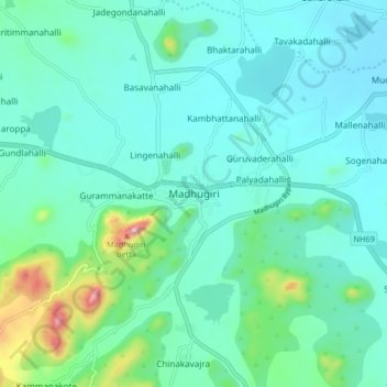
Name: Madhugiri topographic map, elevation, terrain.
Location: Madhugiri, Madhugiri taluk, Tumakuru, Karnataka, 572132, India (13.62018 77.17409 13.70018 77.25409)
Average elevation: 2,569 ft
Minimum elevation: 2,303 ft
Maximum elevation: 3,825 ft
Make a donation
Gear up for your next adventure:
As an Amazon Associate, this site earns from qualifying purchases at no extra cost to you.