
Make a donation
Gear up for your next adventure:
As an Amazon Associate, this site earns from qualifying purchases at no extra cost to you.
Wegfurt topographic map
Click on the map to display elevation.
Make a donation
Gear up for your next adventure:
As an Amazon Associate, this site earns from qualifying purchases at no extra cost to you.
Wegfurt
Das Pfarrdorf liegt circa sechs Kilometer südöstlich von Bischofsheim in der Rhön im Tal der Brend auf einer Höhe von 348 m ü. NHN. Etwa neun Kilometer nordöstlich verläuft die Landesgrenze zu Hessen. Die Bundesstraße 279 umgeht den Ortskern auf der nordöstlichen Seite.
Make a donation
Gear up for your next adventure:
As an Amazon Associate, this site earns from qualifying purchases at no extra cost to you.
About this map
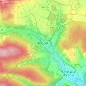
Name: Wegfurt topographic map, elevation, terrain.
Average elevation: 1,299 ft
Minimum elevation: 1,001 ft
Maximum elevation: 1,637 ft
Make a donation
Gear up for your next adventure:
As an Amazon Associate, this site earns from qualifying purchases at no extra cost to you.
Other topographic maps
Click on a map to view its topography, its elevation and its terrain.
97653
Deutschland > Bayern > Landkreis Rhön-Grabfeld > Bischofsheim in der Rhön
Average elevation: 2,018 ft