
Make a donation
Gear up for your next adventure:
As an Amazon Associate, this site earns from qualifying purchases at no extra cost to you.
Unterschleißheim topographic map
Click on the map to display elevation.
Make a donation
Gear up for your next adventure:
As an Amazon Associate, this site earns from qualifying purchases at no extra cost to you.
About this map
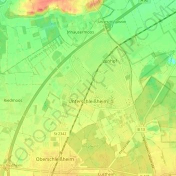
Name: Unterschleißheim topographic map, elevation, terrain.
Location: Unterschleißheim, Landkreis München, Bavaria, 85716, Germany (48.25513 11.51383 48.29919 11.59672)
Average elevation: 1,558 ft
Minimum elevation: 1,480 ft
Maximum elevation: 1,637 ft
Make a donation
Gear up for your next adventure:
As an Amazon Associate, this site earns from qualifying purchases at no extra cost to you.
Other topographic maps
Click on a map to view its topography, its elevation and its terrain.
Deisenhofen
Germany > Bavaria > Landkreis München > Oberhaching > Deisenhofen
Average elevation: 1,942 ft
Feldkirchen
Germany > Bavaria > Landkreis München > Feldkirchen > Feldkirchen
Average elevation: 1,719 ft