
Make a donation
Gear up for your next adventure:
As an Amazon Associate, this site earns from qualifying purchases at no extra cost to you.
Qorveh topographic map
Click on the map to display elevation.
Make a donation
Gear up for your next adventure:
As an Amazon Associate, this site earns from qualifying purchases at no extra cost to you.
Qorveh
Qorveh is home to numerous peaks and elevations. Among them, the most noteworthy are Mount Parishaan, Mount Badr, Panjeh Ali, Ebrahim Attar, Yousef Siah, Shaban Kechal, Khersa Rih, and Seh Zardeh. The most significant of these are Mount Badr and Mount Parishaan.
Make a donation
Gear up for your next adventure:
As an Amazon Associate, this site earns from qualifying purchases at no extra cost to you.
About this map
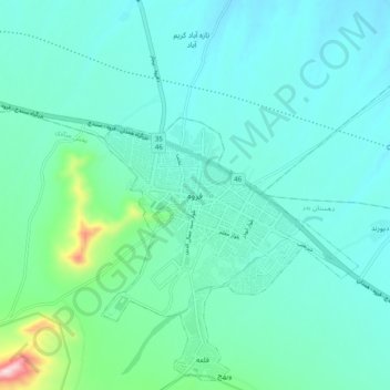
Name: Qorveh topographic map, elevation, terrain.
Average elevation: 6,309 ft
Minimum elevation: 6,089 ft
Maximum elevation: 7,510 ft
Make a donation
Gear up for your next adventure:
As an Amazon Associate, this site earns from qualifying purchases at no extra cost to you.