
Make a donation
Gear up for your next adventure:
As an Amazon Associate, this site earns from qualifying purchases at no extra cost to you.
Hochalmspitze topographic map
Click on the map to display elevation.
Make a donation
Gear up for your next adventure:
As an Amazon Associate, this site earns from qualifying purchases at no extra cost to you.
Hochalmspitze
La Hochalmspitze est un sommet des Alpes, à 3 360 m d'altitude, le point culminant du chaînon d'Ankogel dans les Hohe Tauern, en Autriche (land de Carinthie). Parfois dénommée « la Reine des Tauern », elle est avec le Grossglockner considérée comme l'un des sommets les plus importants du massif.
Make a donation
Gear up for your next adventure:
As an Amazon Associate, this site earns from qualifying purchases at no extra cost to you.
About this map
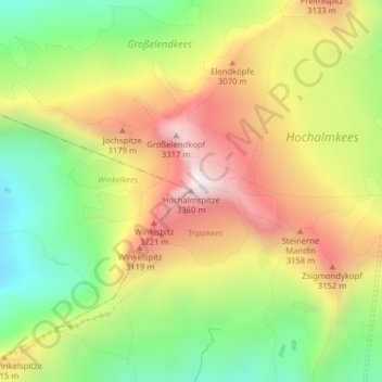
Name: Hochalmspitze topographic map, elevation, terrain.
Average elevation: 9,377 ft
Minimum elevation: 7,940 ft
Maximum elevation: 10,915 ft
Make a donation
Gear up for your next adventure:
As an Amazon Associate, this site earns from qualifying purchases at no extra cost to you.