Geolocate

Ica topographic map

Click on the map to display elevation.

About this map

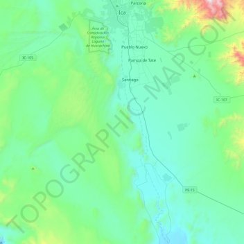
Name: Ica topographic map, elevation, terrain.

Location: Ica, Province of Ica, Ica, Peru (-14.49006 -76.07233 -14.04170 -75.71727)

Average elevation: 1,716 ft

Minimum elevation: 866 ft

Maximum elevation: 6,250 ft

Other topographic maps

Click on a map to view its topography, its elevation and its terrain.

Tambilla

Peru > Ica > Chavín

Average elevation: 7,260 ft

Mendoza

Peru > Ica

Average elevation: 417 ft

Star

Peru > Ica > San Miguel de la Pascana > entrada al ingenio

Average elevation: 1,362 ft

La Franja

Peru > Ica > Santiago > La Franja

Average elevation: 1,385 ft

San Miguel de la Pascana

Peru > Ica

Average elevation: 1,332 ft

Giant

Peru > Ica > Nazca

Average elevation: 1,742 ft

Symbols

Peru > Ica > San Francisco > entrada al ingenio

Average elevation: 1,821 ft

entrada al ingenio

Peru > Ica > San Miguel de la Pascana

Average elevation: 1,312 ft

Gear up for your next adventure:

🪶Compact Camp Shovel - Folding shovel for campsite tasks
🧷Carabiner Set - Durable clips for gear attachment
🎁Geography Themed Gifts - Unique gift ideas for map lovers and geography enthusiasts
🧯Emergency Survival Kit - All‑in‑one survival essentials for the backcountry
🪶Trail Camera - Capture wildlife on your hikes

As an Amazon Associate, this site earns from qualifying purchases at no extra cost to you.