
Make a donation
Gear up for your next adventure:
As an Amazon Associate, this site earns from qualifying purchases at no extra cost to you.
Maevatanana topographic map
Click on the map to display elevation.
Make a donation
Gear up for your next adventure:
As an Amazon Associate, this site earns from qualifying purchases at no extra cost to you.
About this map
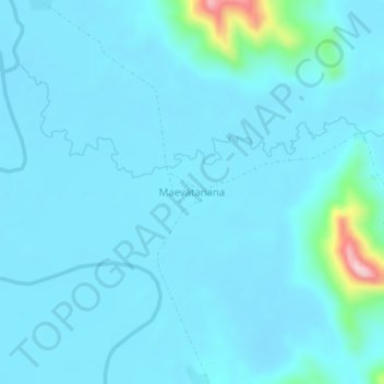
Name: Maevatanana topographic map, elevation, terrain.
Location: Maevatanana, Diana Region, Antsiranana Province, Madagascar (-13.90305 48.50886 -13.86305 48.54886)
Average elevation: 164 ft
Minimum elevation: 92 ft
Maximum elevation: 932 ft
Make a donation
Gear up for your next adventure:
As an Amazon Associate, this site earns from qualifying purchases at no extra cost to you.
Other topographic maps
Click on a map to view its topography, its elevation and its terrain.
Nosy Komba
Madagascar > Diana Region > Ampangorina
French settler-colonial efforts on Nosy Be were persistently hampered by outbreaks of diseases such as malaria, cholera, and smallpox. To remedy this, a convalescence for French settlers was built on the adjacent Nosy Komba in 1841, immediately following the French annexation of the region, with an upgraded…
Average elevation: 436 ft
Make a donation
Gear up for your next adventure:
As an Amazon Associate, this site earns from qualifying purchases at no extra cost to you.
Make a donation
Gear up for your next adventure:
As an Amazon Associate, this site earns from qualifying purchases at no extra cost to you.