Geolocate

Sakti topographic map

Click on the map to display elevation.

About this map

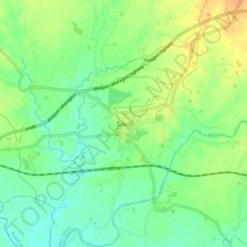
Name: Sakti topographic map, elevation, terrain.

Location: Sakti, Sakti Tahsil, Sakti, Chhattisgarh, 495689, India (21.98626 82.91983 22.06626 82.99983)

Average elevation: 778 ft

Minimum elevation: 732 ft

Maximum elevation: 840 ft

Gear up for your next adventure:

🎒Waterproof Dry Bags - Keep your electronics and maps dry inside your pack
🧭Outdoor Navigation Book - Learn advanced navigation skills
🕶️GPS Smartphone Mount - Secure mount for phone navigation
🎁Geography Themed Gifts - Unique gift ideas for map lovers and geography enthusiasts
📦Dry Bags Set - Waterproof storage for electronics and clothes

As an Amazon Associate, this site earns from qualifying purchases at no extra cost to you.