
Make a donation
Gear up for your next adventure:
As an Amazon Associate, this site earns from qualifying purchases at no extra cost to you.
Puertomingalvo topographic map
Click on the map to display elevation.
Make a donation
Gear up for your next adventure:
As an Amazon Associate, this site earns from qualifying purchases at no extra cost to you.
Puertomingalvo
Puertomingalvo is a municipality located at high elevation in the province of Teruel, Aragon, Spain. According to the 2004 census (INE), the municipality has a population of 182 inhabitants.
Make a donation
Gear up for your next adventure:
As an Amazon Associate, this site earns from qualifying purchases at no extra cost to you.
About this map
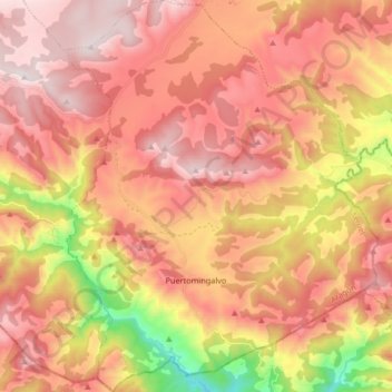
Name: Puertomingalvo topographic map, elevation, terrain.
Location: Puertomingalvo, Gúdar-Javalambre, Teruel, Aragon, Spain (40.22873 -0.51432 40.35507 -0.38224)
Average elevation: 4,551 ft
Minimum elevation: 2,572 ft
Maximum elevation: 5,794 ft
Make a donation
Gear up for your next adventure:
As an Amazon Associate, this site earns from qualifying purchases at no extra cost to you.
Other topographic maps
Click on a map to view its topography, its elevation and its terrain.