
Make a donation
Gear up for your next adventure:
As an Amazon Associate, this site earns from qualifying purchases at no extra cost to you.
Massemen topographic map
Click on the map to display elevation.
Make a donation
Gear up for your next adventure:
As an Amazon Associate, this site earns from qualifying purchases at no extra cost to you.
Massemen
Massemen ligt op de grens van Zandig Vlaanderen en Zandlemig Vlaanderen. De hoogte varieert van 10 tot 29 meter. De belangrijkste waterloop is de Molenbeek welke uitmondt in de Schelde.
Make a donation
Gear up for your next adventure:
As an Amazon Associate, this site earns from qualifying purchases at no extra cost to you.
About this map
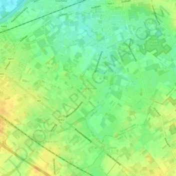
Name: Massemen topographic map, elevation, terrain.
Location: Massemen, Wetteren, Dendermonde, Oost-Vlaanderen, België (50.96935 3.84539 50.99269 3.90388)
Average elevation: 49 ft
Minimum elevation: 3 ft
Maximum elevation: 98 ft
Make a donation
Gear up for your next adventure:
As an Amazon Associate, this site earns from qualifying purchases at no extra cost to you.
Other topographic maps
Click on a map to view its topography, its elevation and its terrain.
Provinciaal Domein "Den Blakken"
België > Oost-Vlaanderen > Dendermonde > Wetteren
Average elevation: 33 ft
Ten Ede
België > Oost-Vlaanderen > Dendermonde > Wetteren
Het veer bevond zich bij de Brugstraat, ongeveer op de plaats van de oude passerelle (die van 1957 tot 2018 dienst deed). Niet toevallig was dit ter hoogte van de wijk Voorde, waarvan de naam erop wijst dat bij deze plek de Schelde voorheen al het makkelijkst over te steken was. In 1571 was er een brug…
Average elevation: 20 ft