
Make a donation
Gear up for your next adventure:
As an Amazon Associate, this site earns from qualifying purchases at no extra cost to you.
Stadt Bludenz topographic map
Click on the map to display elevation.
Make a donation
Gear up for your next adventure:
As an Amazon Associate, this site earns from qualifying purchases at no extra cost to you.
About this map
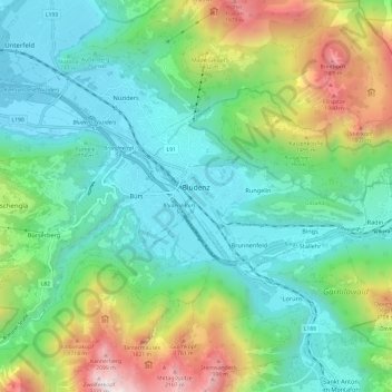
Name: Stadt Bludenz topographic map, elevation, terrain.
Location: Stadt Bludenz, Bezirk Bludenz, Vorarlberg, 6700, Austria (47.12491 9.80230 47.17752 9.92269)
Average elevation: 3,291 ft
Minimum elevation: 1,713 ft
Maximum elevation: 7,385 ft
Make a donation
Gear up for your next adventure:
As an Amazon Associate, this site earns from qualifying purchases at no extra cost to you.
Other topographic maps
Click on a map to view its topography, its elevation and its terrain.
Stuben
Austria > Vorarlberg > Bezirk Bludenz
Stuben am Arlberg is a winter sports resort in the town of Klösterle in the westernmost Austrian province of Vorarlberg. It is located at an altitude of 1,410 meters and had 90 inhabitants (as of 1 January 2019).
Average elevation: 6,138 ft
Außerziggam
Austria > Vorarlberg > Bezirk Bludenz > Gemeinde Sankt Gallenkirch > Sankt Gallenkirch > Außerziggam
Average elevation: 3,953 ft