
Stuben topographic map
Click on the map to display elevation.
Stuben
Stuben am Arlberg is a winter sports resort in the town of Klösterle in the westernmost Austrian province of Vorarlberg. It is located at an altitude of 1,410 meters and had 90 inhabitants (as of 1 January 2019).
About this map
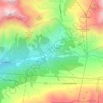
Name: Stuben topographic map, elevation, terrain.
Location: Stuben, Klösterle, Bezirk Bludenz, Vorarlberg, 6762, Austria (47.11941 10.13983 47.15941 10.17983)
Average elevation: 6,138 ft
Minimum elevation: 4,196 ft
Maximum elevation: 8,652 ft
Other topographic maps
Click on a map to view its topography, its elevation and its terrain.
Gemeinde Lech
Austria > Vorarlberg > Bezirk Bludenz
The altitude of 1444 m for the village refers to the location of the old church on a hill. 14.1% of the municipal area is forested, 58% of the area is Alpine. Geographically and historically, Lech belongs to the Hochtannberg region, formerly Tannberg, but in terms of tourism the municipality is part of the…
Average elevation: 6,388 ft