
Thank you for supporting this site ❤️
Make a donation
Make a donation
Gear up for your next adventure:
As an Amazon Associate, this site earns from qualifying purchases at no extra cost to you.
Yaruquíes topographic map
Click on the map to display elevation.
Thank you for supporting this site ❤️
Make a donation
Make a donation
Gear up for your next adventure:
As an Amazon Associate, this site earns from qualifying purchases at no extra cost to you.
About this map
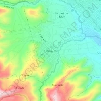
Name: Yaruquíes topographic map, elevation, terrain.
Location: Yaruquíes, Riobamba, Chimborazo, 060112, Ecuador (-1.70872 -78.69620 -1.66872 -78.65620)
Average elevation: 9,380 ft
Minimum elevation: 8,911 ft
Maximum elevation: 10,269 ft
Thank you for supporting this site ❤️
Make a donation
Make a donation
Gear up for your next adventure:
As an Amazon Associate, this site earns from qualifying purchases at no extra cost to you.
Other topographic maps
Click on a map to view its topography, its elevation and its terrain.
Parque Lineal Chibunga
Ecuador > Chimborazo > Riobamba > Riobamba > Santa Cruz
Average elevation: 9,012 ft