
Tretes topographic map
Click on the map to display elevation.
About this map
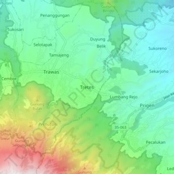
Name: Tretes topographic map, elevation, terrain.
Location: Tretes, Mojokerto, East Java, Java, 61375, Indonesia (-7.71222 112.57264 -7.63222 112.65264)
Average elevation: 2,621 ft
Minimum elevation: 955 ft
Maximum elevation: 6,985 ft
Other topographic maps
Click on a map to view its topography, its elevation and its terrain.