Geolocate

Grimma topographic map

Click on the map to display elevation.

About this map

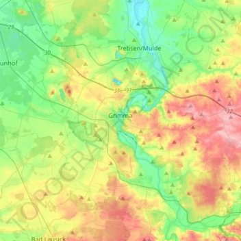
Name: Grimma topographic map, elevation, terrain.

Location: Grimma, Landkreis Leipzig, Saxony, 04668, Germany (51.15649 12.63978 51.31250 12.93169)

Average elevation: 531 ft

Minimum elevation: 377 ft

Maximum elevation: 774 ft

Other topographic maps

Click on a map to view its topography, its elevation and its terrain.

Oellschütz

Germany > Saxony > Landkreis Leipzig > Groitzsch > Hohendorf

Average elevation: 453 ft

Gear up for your next adventure:

🎒Outdoor Daypacks - Lightweight backpacks designed for carrying maps and essential gear
🔭Stargazing Telescopes - Perfect for camping in low-light pollution areas shown on maps
🧼Biodegradable Camping Soap - Eco‑friendly soap for outdoor hygiene
🌎3D Topographic Globes - Raised relief globes for a tactile understanding of geography
🧭Map Reading Tools - Tools and kits for map navigation

As an Amazon Associate, this site earns from qualifying purchases at no extra cost to you.