
Whitney Estates topographic map
Click on the map to display elevation.
About this map
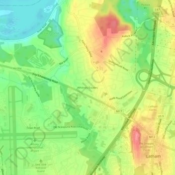
Name: Whitney Estates topographic map, elevation, terrain.
Average elevation: 289 ft
Minimum elevation: 164 ft
Maximum elevation: 430 ft
Albany County trails, hiking, mountain biking, running and outdoor activities
Other topographic maps
Click on a map to view its topography, its elevation and its terrain.
Village of Menands
United States > New York > Albany County > Town of Colonie
Average elevation: 112 ft
Village of Green Island
United States > New York > Albany County > Town of Colonie
Average elevation: 62 ft
Siena College
United States > New York > Albany County > Town of Colonie > Newtonville
Average elevation: 322 ft
Village of Menands
United States > New York > Albany County > Town of Colonie
Average elevation: 112 ft