
Make a donation
Gear up for your next adventure:
As an Amazon Associate, this site earns from qualifying purchases at no extra cost to you.
Nozawaonsen topographic map
Click on the map to display elevation.
Make a donation
Gear up for your next adventure:
As an Amazon Associate, this site earns from qualifying purchases at no extra cost to you.
Nozawaonsen
Nozawaonsen is located in mountainous northeastern Nagano Prefecture, about one hour's drive from Nagano City. To the south it borders Kijimadaira along the ridge of Mount Kenashi. To the west side the Chikuma River, the longest river in Japan, which forms a border of the village with the city of Iiyama. The north and the east borders Sakae village. The altitude of Nozawaonsen ranges from 300 m above sea level at the lowest, to about 600 m in the village, and 1,650 m at the peak of Mount Kenashi.
Make a donation
Gear up for your next adventure:
As an Amazon Associate, this site earns from qualifying purchases at no extra cost to you.
About this map
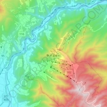
Name: Nozawaonsen topographic map, elevation, terrain.
Average elevation: 2,329 ft
Minimum elevation: 912 ft
Maximum elevation: 5,364 ft
Make a donation
Gear up for your next adventure:
As an Amazon Associate, this site earns from qualifying purchases at no extra cost to you.