
Make a donation
Gear up for your next adventure:
As an Amazon Associate, this site earns from qualifying purchases at no extra cost to you.
Riddle topographic map
Click on the map to display elevation.
Make a donation
Gear up for your next adventure:
As an Amazon Associate, this site earns from qualifying purchases at no extra cost to you.
Riddle
Riddle is about 25 miles (40 km) south of Roseburg and 220 miles (350 km) south of Portland. It lies about 4 miles (6.4 km) west of Oregon Route 99 (Interstate 5) at an elevation of about 700 feet (210 m) above sea level. Cow Creek flows by Riddle before entering the nearby South Umpqua River.
Make a donation
Gear up for your next adventure:
As an Amazon Associate, this site earns from qualifying purchases at no extra cost to you.
About this map
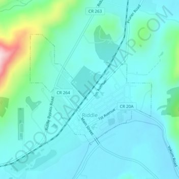
Name: Riddle topographic map, elevation, terrain.
Location: Riddle, Douglas County, Oregon, United States (42.94641 -123.37653 42.96311 -123.35149)
Average elevation: 807 ft
Minimum elevation: 640 ft
Maximum elevation: 1,654 ft
Make a donation
Gear up for your next adventure:
As an Amazon Associate, this site earns from qualifying purchases at no extra cost to you.