
Make a donation
Gear up for your next adventure:
As an Amazon Associate, this site earns from qualifying purchases at no extra cost to you.
Col du Pfaffenschlick topographic map
Click on the map to display elevation.
Make a donation
Gear up for your next adventure:
As an Amazon Associate, this site earns from qualifying purchases at no extra cost to you.
Col du Pfaffenschlick
Le col du Pfaffenschlick se situe dans les Vosges du Nord, dans le département français du Bas-Rhin, au carrefour des RD 51 et 65 entre Climbach et Lobsann d'une part, et Lembach et Schœnenbourg d'autre part. La route franchit le massif du Hochwald et passe à une altitude de 371 mètres.
Make a donation
Gear up for your next adventure:
As an Amazon Associate, this site earns from qualifying purchases at no extra cost to you.
About this map
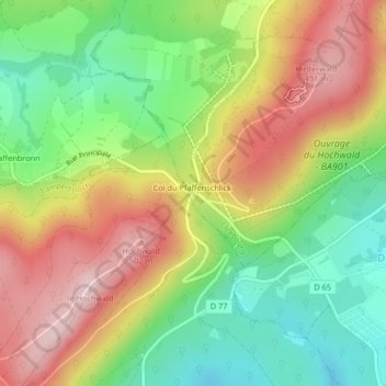
Name: Col du Pfaffenschlick topographic map, elevation, terrain.
Average elevation: 1,158 ft
Minimum elevation: 722 ft
Maximum elevation: 1,667 ft
Make a donation
Gear up for your next adventure:
As an Amazon Associate, this site earns from qualifying purchases at no extra cost to you.