
Thank you for supporting this site ❤️
Make a donation
Make a donation
Gear up for your next adventure:
As an Amazon Associate, this site earns from qualifying purchases at no extra cost to you.
Tham topographic map
Click on the map to display elevation.
Thank you for supporting this site ❤️
Make a donation
Make a donation
Gear up for your next adventure:
As an Amazon Associate, this site earns from qualifying purchases at no extra cost to you.
About this map
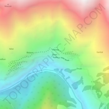
Name: Tham topographic map, elevation, terrain.
Location: Tham, Atholi (Paddar), Kishtwar, Jammu and Kashmir, India (33.14452 76.26597 33.18452 76.30597)
Average elevation: 9,416 ft
Minimum elevation: 6,421 ft
Maximum elevation: 13,835 ft
Thank you for supporting this site ❤️
Make a donation
Make a donation
Gear up for your next adventure:
As an Amazon Associate, this site earns from qualifying purchases at no extra cost to you.