Geolocate

Remscheid topographic map

Click on the map to display elevation.

About this map

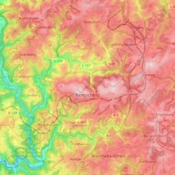
Name: Remscheid topographic map, elevation, terrain.

Location: Remscheid, North Rhine-Westphalia, Germany (51.14229 7.13102 51.22683 7.30932)

Average elevation: 869 ft

Minimum elevation: 279 ft

Maximum elevation: 1,250 ft

Other topographic maps

Click on a map to view its topography, its elevation and its terrain.

Losheim

Germany > North Rhine-Westphalia > Kreis Euskirchen

Average elevation: 1,909 ft

Hummerbruch

Germany > North Rhine-Westphalia > Kreis Lippe

Average elevation: 856 ft

Bosseborn

Germany > North Rhine-Westphalia > Kreis Höxter

Average elevation: 968 ft

Moll

Germany > North Rhine-Westphalia > Kreis Viersen > Kempen > Unterweiden

Average elevation: 125 ft

Gear up for your next adventure:

🦺Reflective Outdoor Gear - Safety gear for low‑light conditions
🏥Hiking First Aid Kits - Comprehensive medical kits for remote trail injuries
🧭Outdoor Navigation Book - Learn advanced navigation skills
🎒Outdoor Daypacks - Lightweight backpacks designed for carrying maps and essential gear
🎒Hydration Pack - Hands‑free water reservoir for long hikes

As an Amazon Associate, this site earns from qualifying purchases at no extra cost to you.