
Thank you for supporting this site ❤️
Make a donation
Make a donation
Gear up for your next adventure:
As an Amazon Associate, this site earns from qualifying purchases at no extra cost to you.
Stuorgiedde - Storjorda topographic map
Click on the map to display elevation.
Thank you for supporting this site ❤️
Make a donation
Make a donation
Gear up for your next adventure:
As an Amazon Associate, this site earns from qualifying purchases at no extra cost to you.
About this map
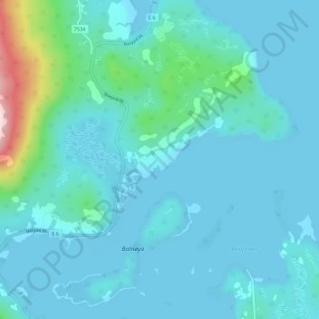
Name: Stuorgiedde - Storjorda topographic map, elevation, terrain.
Location: Stuorgiedde - Storjorda, Hamarøy, Nordland, 8275, Norway (68.18294 16.05359 68.22294 16.09359)
Average elevation: 138 ft
Minimum elevation: -3 ft
Maximum elevation: 1,234 ft
Thank you for supporting this site ❤️
Make a donation
Make a donation
Gear up for your next adventure:
As an Amazon Associate, this site earns from qualifying purchases at no extra cost to you.
Other topographic maps
Click on a map to view its topography, its elevation and its terrain.