
Make a donation
Gear up for your next adventure:
As an Amazon Associate, this site earns from qualifying purchases at no extra cost to you.
Elst topographic map
Click on the map to display elevation.
Make a donation
Gear up for your next adventure:
As an Amazon Associate, this site earns from qualifying purchases at no extra cost to you.
About this map
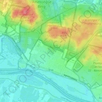
Name: Elst topographic map, elevation, terrain.
Location: Elst, Rhenen, Utrecht, Nederland (51.97157 5.47766 52.01231 5.54528)
Average elevation: 79 ft
Minimum elevation: 3 ft
Maximum elevation: 236 ft
Make a donation
Gear up for your next adventure:
As an Amazon Associate, this site earns from qualifying purchases at no extra cost to you.
Other topographic maps
Click on a map to view its topography, its elevation and its terrain.
Grebbeberg
Topografisch kaartbeeld van de Grebbeberg en de Blauwe Kamer, december 2015. Klik voor een vergroting.
Average elevation: 52 ft
Make a donation
Gear up for your next adventure:
As an Amazon Associate, this site earns from qualifying purchases at no extra cost to you.