Geolocate

Natural Bridge topographic map

Click on the map to display elevation.

About this map

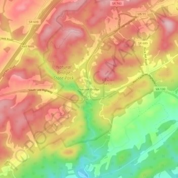
Name: Natural Bridge topographic map, elevation, terrain.

Location: Natural Bridge, Rockbridge County, Virginia, 24578, United States (37.61019 -79.56319 37.65019 -79.52319)

Average elevation: 1,171 ft

Minimum elevation: 741 ft

Maximum elevation: 1,463 ft

Rockbridge County trails, hiking, mountain biking, running and outdoor activities

Other topographic maps

Click on a map to view its topography, its elevation and its terrain.

Goshen Scout Reservation

United States > Virginia > Rockbridge County

The first year camper program, called Bowman Brigade, focuses on the rank requirements of Scout, Tenderfoot, Second Class, and First Class. Staff introduce participants to different merit badges. The older Scout program with an age requirement of 14, called Bowman Vets, focuses on wakeboarding, action archery,…

Average elevation: 1,673 ft

Goshen

United States > Virginia > Rockbridge County

Average elevation: 1,549 ft

Glasgow

United States > Virginia > Rockbridge County

Average elevation: 932 ft

Goshen

United States > Virginia > Rockbridge County

Average elevation: 1,549 ft

Irish Creek

United States > Virginia > Rockbridge County

Average elevation: 1,637 ft

Gear up for your next adventure:

🧣Hiking Neck Gaiter - Multi‑use neck protection for outdoor weather
🔋Rechargeable Batteries - Power up your outdoor devices
🦟Ultrasonic Repellers - Create a bug-free zone at your camp or rest stop
🚑Emergency Bivvies - Heat-reflective sleeping bags for survival situations
🪶Paracord Bracelet - Survival bracelet with built‑in tools

As an Amazon Associate, this site earns from qualifying purchases at no extra cost to you.