Geolocate

Sojat topographic map

Click on the map to display elevation.

Sojat

Sojat is located at 25°55′N 73°40′E / 25.92°N 73.67°E / 25.92; 73.67. It has an average elevation of 257 metres (843 feet). The whole region lies on the way of "Aravali hills range" which is the oldest hill range in India.

Wikipedia (CC-BY-SA 3.0)

About this map

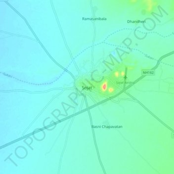
Name: Sojat topographic map, elevation, terrain.

Location: Sojat, Sojat Tehsil, Pali, Rajasthan, 306104, India (25.88459 73.62524 25.96459 73.70524)

Average elevation: 886 ft

Minimum elevation: 850 ft

Maximum elevation: 1,119 ft

Gear up for your next adventure:

🔥Fast-Boil Camping Stoves - Efficient cooking systems for quick trail meals
🛡️Insect Repellent - Protection against bugs during outdoor activities
📶Vehicle Signal Boosters - Improve reception in rural areas while driving to trailheads
🧥Waterproof Jacket for Hiking - Breathable and rugged rain jacket for outdoor excursions
🪶Paracord Bracelet - Survival bracelet with built‑in tools

As an Amazon Associate, this site earns from qualifying purchases at no extra cost to you.