
Maple Grove topographic map
Click on the map to display elevation.
About this map
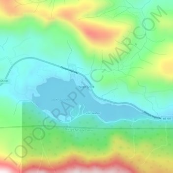
Name: Maple Grove topographic map, elevation, terrain.
Location: Maple Grove, Clallam County, Washington, United States (48.06120 -123.72520 48.10120 -123.68520)
Average elevation: 1,263 ft
Minimum elevation: 482 ft
Maximum elevation: 2,933 ft
Clallam County trails, hiking, mountain biking, running and outdoor activities
Other topographic maps
Click on a map to view its topography, its elevation and its terrain.
Port Angeles East
United States > Washington > Clallam County > Mount Pleasant
Average elevation: 194 ft
Bell Hill
United States > Washington > Clallam County > Bell Hill
Bell Hill is located in eastern Clallam County and is bordered to the north by the city of Sequim. The community is named for the hill that it sits on, which rises to an elevation of over 1,000 feet (300 m) above sea level, or more than 800 feet (240 m) above the center of Sequim. Bell Hill actually has two…
Average elevation: 456 ft