
Make a donation
Gear up for your next adventure:
As an Amazon Associate, this site earns from qualifying purchases at no extra cost to you.
Gusinje topographic map
Click on the map to display elevation.
Make a donation
Gear up for your next adventure:
As an Amazon Associate, this site earns from qualifying purchases at no extra cost to you.
Gusinje
The town is located in the Plav-Gusinje area, part of the upper Lim valley in the Accursed Mountains range at an elevation of 1,014 m. Zla Kolata, the highest mountain in Montenegro, is about 10 km south of Gusinje in the Prokletije National Park.
Make a donation
Gear up for your next adventure:
As an Amazon Associate, this site earns from qualifying purchases at no extra cost to you.
About this map
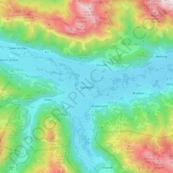
Name: Gusinje topographic map, elevation, terrain.
Location: Gusinje, Gusinje Municipality, 84326, Montenegro (42.52377 19.79325 42.60377 19.87325)
Average elevation: 4,249 ft
Minimum elevation: 2,969 ft
Maximum elevation: 7,185 ft
Make a donation
Gear up for your next adventure:
As an Amazon Associate, this site earns from qualifying purchases at no extra cost to you.
Other topographic maps
Click on a map to view its topography, its elevation and its terrain.
Accursed Mountains
Montenegro > Gusinje Municipality
The Accursed Mountains are a typical Dinaric karst high mountain range with a pronounced steep topography and glacial features. Maximum relief differences of 1,800 metres (5,900 ft) are found in the Valbona, Grbaja and Ropojani and Cem valleys. Overhanging walls and ridges forming pointed peaks are typical of…
Average elevation: 5,499 ft