
Make a donation
Gear up for your next adventure:
As an Amazon Associate, this site earns from qualifying purchases at no extra cost to you.
Okhahlamba Local Municipality topographic map
Click on the map to display elevation.
Make a donation
Gear up for your next adventure:
As an Amazon Associate, this site earns from qualifying purchases at no extra cost to you.
About this map
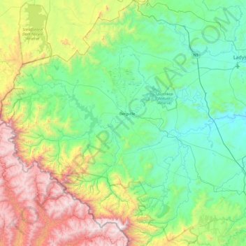
Name: Okhahlamba Local Municipality topographic map, elevation, terrain.
Average elevation: 5,197 ft
Minimum elevation: 3,153 ft
Maximum elevation: 11,066 ft
Make a donation
Gear up for your next adventure:
As an Amazon Associate, this site earns from qualifying purchases at no extra cost to you.
Other topographic maps
Click on a map to view its topography, its elevation and its terrain.
Estcourt
South Africa > KwaZulu-Natal > Uthukela District Municipality > Umtshezi Local Municipality
Average elevation: 3,950 ft
Weenen
South Africa > KwaZulu-Natal > Uthukela District Municipality > Umtshezi Local Municipality
Average elevation: 2,854 ft
Tugela Falls
South Africa > KwaZulu-Natal > Uthukela District Municipality > Okhahlamba Local Municipality
First, many now believe that Angel Falls is not as tall as was claimed in the initial survey carried out by American journalist Ruth Robertson in 1949. The quoted figure of 979 m (3,212 ft) corresponds almost precisely with the difference in altitude between the top of the falls and the confluence of the Rio…
Average elevation: 9,098 ft
Make a donation
Gear up for your next adventure:
As an Amazon Associate, this site earns from qualifying purchases at no extra cost to you.
Albert's falls
South Africa > KwaZulu-Natal > Uthukela District Municipality > Okhahlamba Local Municipality
Average elevation: 5,719 ft
Njesuthi
South Africa > KwaZulu-Natal > Uthukela District Municipality > Imbabazane Local Municipality
Average elevation: 10,433 ft
Champagne Castle
South Africa > KwaZulu-Natal > Uthukela District Municipality > Okhahlamba Local Municipality
Average elevation: 10,177 ft
Wasbank
South Africa > KwaZulu-Natal > Uthukela District Municipality > Indaka Local Municipality
Average elevation: 3,514 ft
Make a donation
Gear up for your next adventure:
As an Amazon Associate, this site earns from qualifying purchases at no extra cost to you.
Colenso
South Africa > KwaZulu-Natal > Uthukela District Municipality > Emnambithi/Ladysmith Local Municipality
Average elevation: 3,173 ft
Umtshezi
South Africa > KwaZulu-Natal > Uthukela District Municipality > Imbabazane Local Municipality
Average elevation: 6,988 ft
Colenso
South Africa > KwaZulu-Natal > Uthukela District Municipality > Emnambithi/Ladysmith Local Municipality
Average elevation: 3,173 ft
Estcourt
South Africa > KwaZulu-Natal > Uthukela District Municipality > Umtshezi Local Municipality
Average elevation: 3,950 ft
Make a donation
Gear up for your next adventure:
As an Amazon Associate, this site earns from qualifying purchases at no extra cost to you.
WINTERBURN
South Africa > KwaZulu-Natal > Uthukela District Municipality > Okhahlamba Local Municipality
Average elevation: 4,314 ft
Cathkin Peak
South Africa > KwaZulu-Natal > Uthukela District Municipality > Okhahlamba Local Municipality
Average elevation: 8,727 ft
Crocodile
South Africa > KwaZulu-Natal > Uthukela District Municipality > Okhahlamba Local Municipality
Average elevation: 5,381 ft
Weenen
South Africa > KwaZulu-Natal > Uthukela District Municipality > Umtshezi Local Municipality
Average elevation: 2,854 ft
Make a donation
Gear up for your next adventure:
As an Amazon Associate, this site earns from qualifying purchases at no extra cost to you.
Royal Natal National Park
South Africa > KwaZulu-Natal > Uthukela District Municipality > Okhahlamba Local Municipality > Thendele
Average elevation: 6,132 ft
Van Reenen
South Africa > KwaZulu-Natal > Uthukela District Municipality > Emnambithi/Ladysmith Local Municipality > Van Reenen
Average elevation: 5,453 ft
Hambrook
South Africa > KwaZulu-Natal > Uthukela District Municipality > Okhahlamba Local Municipality
Average elevation: 3,701 ft