
Make a donation
Gear up for your next adventure:
As an Amazon Associate, this site earns from qualifying purchases at no extra cost to you.
Ladysmith topographic map
Click on the map to display elevation.
Make a donation
Gear up for your next adventure:
As an Amazon Associate, this site earns from qualifying purchases at no extra cost to you.
About this map
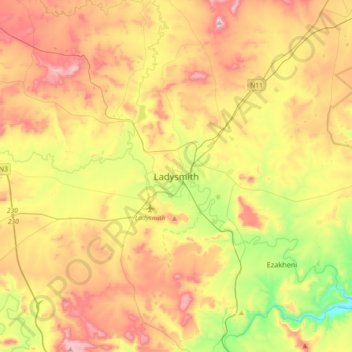
Name: Ladysmith topographic map, elevation, terrain.
Average elevation: 3,593 ft
Minimum elevation: 2,598 ft
Maximum elevation: 4,721 ft
Make a donation
Gear up for your next adventure:
As an Amazon Associate, this site earns from qualifying purchases at no extra cost to you.
Other topographic maps
Click on a map to view its topography, its elevation and its terrain.
Wasbank
South Africa > KwaZulu-Natal > Uthukela District Municipality > Indaka Local Municipality
Average elevation: 3,514 ft
Spioenkop Dam
South Africa > KwaZulu-Natal > Uthukela District Municipality > Okhahlamba Local Municipality
Average elevation: 3,737 ft
Umtshezi Ward 5
South Africa > KwaZulu-Natal > Uthukela District Municipality > Umtshezi Local Municipality
Average elevation: 3,051 ft
Okhahlamba Ward 6
South Africa > KwaZulu-Natal > Uthukela District Municipality > Okhahlamba Local Municipality
Average elevation: 6,243 ft
Make a donation
Gear up for your next adventure:
As an Amazon Associate, this site earns from qualifying purchases at no extra cost to you.
Woodstock Dam
South Africa > KwaZulu-Natal > Uthukela District Municipality > Okhahlamba Local Municipality
Average elevation: 3,911 ft
Okhahlamba Ward 4
South Africa > KwaZulu-Natal > Uthukela District Municipality > Okhahlamba Local Municipality
Average elevation: 4,521 ft
Emnambithi/Ladysmith Local Municipality
South Africa > KwaZulu-Natal > Uthukela District Municipality
Average elevation: 4,081 ft
Okhahlamba Local Municipality
South Africa > KwaZulu-Natal > Uthukela District Municipality
Average elevation: 5,197 ft
Make a donation
Gear up for your next adventure:
As an Amazon Associate, this site earns from qualifying purchases at no extra cost to you.
Umtshezi
South Africa > KwaZulu-Natal > Uthukela District Municipality > Imbabazane Local Municipality
Average elevation: 6,988 ft
Okhahlamba Local Municipality
South Africa > KwaZulu-Natal > Uthukela District Municipality
Average elevation: 5,197 ft
Spioenkop Dam
South Africa > KwaZulu-Natal > Uthukela District Municipality > Okhahlamba Local Municipality
Average elevation: 3,737 ft
Make a donation
Gear up for your next adventure:
As an Amazon Associate, this site earns from qualifying purchases at no extra cost to you.
Emnambithi/Ladysmith Ward 13
South Africa > KwaZulu-Natal > Uthukela District Municipality > Emnambithi/Ladysmith Local Municipality
Average elevation: 3,629 ft
Okhahlamba Local Municipality
South Africa > KwaZulu-Natal > Uthukela District Municipality
Average elevation: 5,197 ft