
Burgos topographic map
Click on the map to display elevation.
Burgos
Another tourist attraction worth mentioning is the historic Cape Bojeador Lighthouse, built during the latter part of the 19th cent South China Sea, it serves as a beacon to passing ships and to local fishermen. Because of its high elevation, it offers travelers with a panoramic view of the rugged coastline of Burgos.
About this map
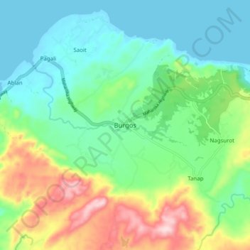
Name: Burgos topographic map, elevation, terrain.
Location: Burgos, Ilocos Norte, Ilocos Region, Philippines (18.47101 120.60363 18.55101 120.68363)
Average elevation: 282 ft
Minimum elevation: -3 ft
Maximum elevation: 938 ft
Other topographic maps
Click on a map to view its topography, its elevation and its terrain.
Pagudpud
The town's topography includes mountains, hills, valleys and flat coastal land.
Average elevation: 233 ft
La Paz Sand Dunes
Philippines > Ilocos Norte > Brgy. 62-B Navotas South > Laoag
Average elevation: 23 ft
Pagudpud
The town's topography includes mountains, hills, valleys and flat coastal land.
Average elevation: 240 ft