
Thank you for supporting this site ❤️
Make a donation
Make a donation
Gear up for your next adventure:
As an Amazon Associate, this site earns from qualifying purchases at no extra cost to you.
Feilenreit topographic map
Click on the map to display elevation.
Thank you for supporting this site ❤️
Make a donation
Make a donation
Gear up for your next adventure:
As an Amazon Associate, this site earns from qualifying purchases at no extra cost to you.
About this map
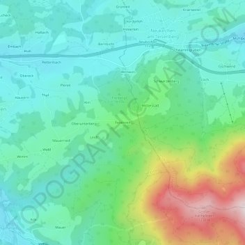
Name: Feilenreit topographic map, elevation, terrain.
Average elevation: 2,595 ft
Minimum elevation: 2,051 ft
Maximum elevation: 4,150 ft
Thank you for supporting this site ❤️
Make a donation
Make a donation
Gear up for your next adventure:
As an Amazon Associate, this site earns from qualifying purchases at no extra cost to you.
Other topographic maps
Click on a map to view its topography, its elevation and its terrain.
83313
Deutschland > Bayern > Landkreis Traunstein > Siegsdorf > Wolfsberg > Starz
Average elevation: 2,349 ft