
Boqueirão topographic map
Click on the map to display elevation.
About this map
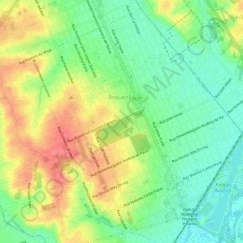
Name: Boqueirão topographic map, elevation, terrain.
Average elevation: 2,936 ft
Minimum elevation: 2,835 ft
Maximum elevation: 3,064 ft
Other topographic maps
Click on a map to view its topography, its elevation and its terrain.
Bosque Gutierrez
Brazil > Paraná > Região Metropolitana de Curitiba > Curitiba
Average elevation: 3,084 ft
Southern carcara
Brazil > Paraná > Região Metropolitana de Curitiba > Curitiba
Average elevation: 2,884 ft