Geolocate

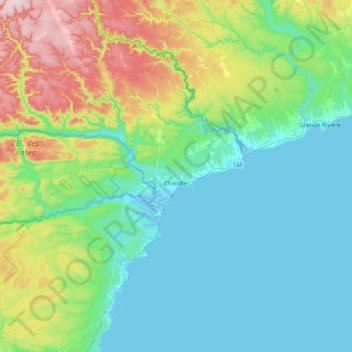
Chandler topographic map

Click on the map to display elevation.

Chandler

The area was first settled in 1729, making it one of the oldest places on the Gaspé coast. It was known over time as Paboc, Pabo, Pabok, Pabeau, and Pas-bos. In 1815, the final spelling of Pabos was assigned in the Description topographique de la province du Bas Canada (Topographical Description of the Province of Lower Canada). The meaning of this name is uncertain, although there are various theories: from the Mi'kmaq word papôg (meaning "playful waters"); a Basque name; from the Spanish pavo; a place in France, home of the first seignoral lord; or from the French words pas[sage] beau (meaning "beautiful passage").

Wikipedia (CC-BY-SA 3.0)

About this map

Name: Chandler topographic map, elevation, terrain.

Location: Chandler, Le Rocher-Percé, Gaspésie–Îles-de-la-Madeleine, Quebec, Canada (48.20641 -64.95756 48.50341 -64.57330)

Average elevation: 351 ft

Minimum elevation: -13 ft

Maximum elevation: 1,457 ft

Other topographic maps

Click on a map to view its topography, its elevation and its terrain.
Île Beau Séjour

Canada > Quebec > Le Rocher-Percé > Chandler

Average elevation: 7 ft

Newport-Ouest

Canada > Quebec > Le Rocher-Percé > Chandler

Average elevation: 125 ft

Bridgeville

Canada > Quebec > Le Rocher-Percé > Percé

Average elevation: 75 ft

Pabos

Canada > Quebec > Le Rocher-Percé > Chandler

Average elevation: 30 ft

Gascons

Canada > Quebec > Le Rocher-Percé

Average elevation: 161 ft

Gear up for your next adventure:

🥇GPS Hiking Watch - Multi‑sport GPS watch with navigation and trail tracking
🧷Carabiner Set - Durable clips for gear attachment
Solar GPS Watches - Advanced multisport watches with built-in topographic maps
🧤Tactile Hiking Gloves - Keep hands warm while operating GPS and smartphone screens
🥤Water Filter Bottle - All‑in‑one filter bottle for safe hydration

As an Amazon Associate, this site earns from qualifying purchases at no extra cost to you.