Geolocate

Salabamba topographic map

Click on the map to display elevation.

About this map

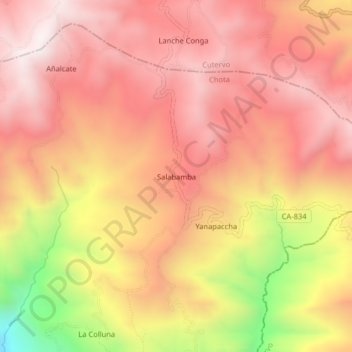
Name: Salabamba topographic map, elevation, terrain.

Location: Salabamba, Cochabamba, Chota, Cajamarca, Perú (-6.46559 -78.84157 -6.42559 -78.80157)

Average elevation: 8,714 ft

Minimum elevation: 6,722 ft

Maximum elevation: 9,718 ft

Other topographic maps

Click on a map to view its topography, its elevation and its terrain.

Provincia de Chota

Perú > Cajamarca > Cochabamba

Average elevation: 7,598 ft

Gear up for your next adventure:

Solar GPS Watches - Advanced multisport watches with built-in topographic maps
🎒Gear Packing Cubes - Organize your backpack efficiently
Backpacking Tent - Lightweight and durable tent for multi‑day hikes
🔦Compact Flashlight - Reliable flashlight for emergencies
🧤Hiking Gloves - Protective gloves for rugged trails

As an Amazon Associate, this site earns from qualifying purchases at no extra cost to you.