
Make a donation
Gear up for your next adventure:
As an Amazon Associate, this site earns from qualifying purchases at no extra cost to you.
Weissenried topographic map
Click on the map to display elevation.
Make a donation
Gear up for your next adventure:
As an Amazon Associate, this site earns from qualifying purchases at no extra cost to you.
About this map
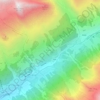
Name: Weissenried topographic map, elevation, terrain.
Location: Weissenried, Blatten, Westlich Raron, Wallis, 3919, Schweiz (46.39807 7.78513 46.43807 7.82513)
Average elevation: 6,480 ft
Minimum elevation: 4,432 ft
Maximum elevation: 9,744 ft
Make a donation
Gear up for your next adventure:
As an Amazon Associate, this site earns from qualifying purchases at no extra cost to you.
Other topographic maps
Click on a map to view its topography, its elevation and its terrain.
Lötschental
Schweiz > Wallis > Westlich Raron > Blatten
Die nördlich begrenzende Gebirgskette bildet der vom Lötschenpass bis zum Hockenhorn (3293 m ü. M.) ansteigende Gasterngrat sowie der östlich daran anschliessende Petersgrat. Gleichzeitig stellt sie die Wasserscheide zwischen Rhone und Aare und somit einen Teil der Europäischen Hauptwasserscheide dar. Die…
Average elevation: 7,267 ft