Geolocate

Rizal topographic map

Click on the map to display elevation.

About this map

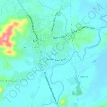
Name: Rizal topographic map, elevation, terrain.

Location: Rizal, Quirino, Cagayan Valley, Philippines (16.56875 121.48861 16.60875 121.52861)

Average elevation: 427 ft

Minimum elevation: 338 ft

Maximum elevation: 928 ft

Gear up for your next adventure:

🪵Folding Camp Saw - Compact saw for wood and campsite work
🚁Photography Drones - Capture stunning aerial views of landforms and topography
🧭Pro Hiking Compasses - High-accuracy liquid-filled compasses for topographic orientation
🌐World Map Poster - Decorative world maps with topographic info
🚪Portable Camp Chair - Foldable chair for comfort at camp

As an Amazon Associate, this site earns from qualifying purchases at no extra cost to you.