Geolocate

Hechingen topographic map

Click on the map to display elevation.

About this map

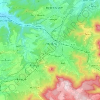
Name: Hechingen topographic map, elevation, terrain.

Location: Hechingen, Gemeindeverwaltungsverband Hechingen, Zollernalbkreis, Baden-Württemberg, 72379, Germany (48.30011 8.89075 48.39081 9.06222)

Average elevation: 1,923 ft

Minimum elevation: 1,352 ft

Maximum elevation: 3,143 ft

Other topographic maps

Click on a map to view its topography, its elevation and its terrain.

Wessingen

Germany > Baden-Württemberg > Zollernalbkreis

Average elevation: 1,844 ft

Wessingen

Germany > Baden-Württemberg > Zollernalbkreis

Average elevation: 1,844 ft

Gear up for your next adventure:

🔭Telescopic Hiking Pole - Adjustable pole for hiking stability
🔦Compact Flashlight - Reliable flashlight for emergencies
🎒Trekking Poles - Sturdy poles for balance and stability on rough terrain
📌Outdoor GPS Map App - Apps and devices for digital topographic navigation
🧴Hand Sanitizer - Keep hands clean while hiking

As an Amazon Associate, this site earns from qualifying purchases at no extra cost to you.