
Make a donation
Gear up for your next adventure:
As an Amazon Associate, this site earns from qualifying purchases at no extra cost to you.
Petzow topographic map
Click on the map to display elevation.
Make a donation
Gear up for your next adventure:
As an Amazon Associate, this site earns from qualifying purchases at no extra cost to you.
Petzow
Bliesendorf mit Resau | Derwitz | Glindow mit Elisabethhöhe | Kemnitz mit Kolonie Zern | Petzow mit Löcknitz und Riegelberg | Phöben | Plötzin mit Neu Plötzin und Plessow | Töplitz mit Alt Töplitz, Eichholz, Göttin, Leest und Neu Töplitz
Make a donation
Gear up for your next adventure:
As an Amazon Associate, this site earns from qualifying purchases at no extra cost to you.
About this map
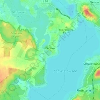
Name: Petzow topographic map, elevation, terrain.
Average elevation: 121 ft
Minimum elevation: 82 ft
Maximum elevation: 226 ft
Make a donation
Gear up for your next adventure:
As an Amazon Associate, this site earns from qualifying purchases at no extra cost to you.
Other topographic maps
Click on a map to view its topography, its elevation and its terrain.
Phöben
Deutschland > Brandenburg > Potsdam-Mittelmark > Werder (Havel)
Bliesendorf mit Resau | Derwitz | Glindow mit Elisabethhöhe | Kemnitz mit Kolonie Zern | Petzow mit Löcknitz und Riegelberg | Phöben | Plötzin mit Neu Plötzin und Plessow | Töplitz mit Alt Töplitz, Eichholz, Göttin, Leest und Neu Töplitz
Average elevation: 115 ft
Kleiner Zernsee
Deutschland > Brandenburg > Potsdam-Mittelmark > Werder (Havel)
Average elevation: 118 ft