Geolocate

Heybridge topographic map

Click on the map to display elevation.

About this map

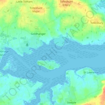
Name: Heybridge topographic map, elevation, terrain.

Location: Heybridge, Maldon, Essex, England, United Kingdom (51.71430 0.66660 51.75106 0.80264)

Average elevation: 26 ft

Minimum elevation: -7 ft

Maximum elevation: 128 ft

Gear up for your next adventure:

🥄Camping Utensil Set - Lightweight utensils for outdoor meals
🔥Plasma Lighters - Windproof lighters that work in any weather condition
🕶️GPS Smartphone Mount - Secure mount for phone navigation
Camping Coffee Makers - Enjoy premium coffee at the summit or campsite
🔭Telescopic Hiking Pole - Adjustable pole for hiking stability

As an Amazon Associate, this site earns from qualifying purchases at no extra cost to you.