Geolocate

Zacha Junction topographic map

Click on the map to display elevation.

About this map

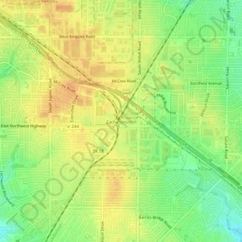
Name: Zacha Junction topographic map, elevation, terrain.

Location: Zacha Junction, Dallas, Dallas County, Texas, 75041, United States (32.84485 -96.68916 32.88485 -96.64916)

Average elevation: 577 ft

Minimum elevation: 512 ft

Maximum elevation: 620 ft

Dallas County trails, hiking, mountain biking, running and outdoor activities

Other topographic maps

Click on a map to view its topography, its elevation and its terrain.

Dealey Plaza

United States > Texas > Dallas County > Dallas

Average elevation: 433 ft

Klyde Warren Park

United States > Texas > Dallas County > Dallas

Average elevation: 466 ft

Pioneer Park

United States > Texas > Dallas County > Dallas

Average elevation: 443 ft

Gear up for your next adventure:

😴Insulated Sleeping Pads - Compact and warm pads for high-elevation camping
🧣Hiking Neck Gaiter - Multi‑use neck protection for outdoor weather
🪶Fire Starter Kit - Reliable fire starter for survival and camping
🔊Portable Camp Speaker - Music and alerts at camp
🛡️Bear Spray Outdoor - Protection in bear country hikes

As an Amazon Associate, this site earns from qualifying purchases at no extra cost to you.