
Rosenbühl topographic map
Interactive map
Click on the map to display elevation.
About this map
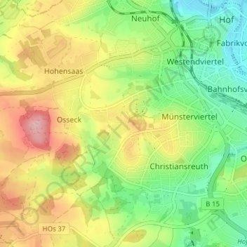
Name: Rosenbühl topographic map, elevation, terrain.
Location: Rosenbühl, Osseck, Hof, Bayern, 95030, Deutschland (50.28503 11.87187 50.32503 11.91187)
Average elevation: 1,768 ft
Minimum elevation: 1,545 ft
Maximum elevation: 2,057 ft
Other topographic maps
Click on a map to view its topography, its elevation and its terrain.
Osseck
Deutschland > Bayern > Hof > Osseck
Osseck, Hof, Bayern, 95030, Deutschland
Average elevation: 1,808 ft