Geolocate

El Indio topographic map

Interactive map

Click on the map to display elevation.

About this map

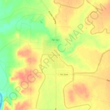
Name: El Indio topographic map, elevation, terrain.

Location: El Indio, Maverick County, Texas, 78860, United States (28.49415 -100.33162 28.53415 -100.29162)

Average elevation: 728 ft

Minimum elevation: 623 ft

Maximum elevation: 787 ft

Other topographic maps

Click on a map to view its topography, its elevation and its terrain.

Eagle Pass

United States > Texas > Maverick County

Eagle Pass, Maverick County, Texas, 78852, United States

Average elevation: 758 ft

Las Quintas Fronterizas

United States > Texas > Maverick County

Las Quintas Fronterizas, Maverick County, Texas, 78853, United States

Average elevation: 778 ft

Victoriano Hernandez Colonia

United States > Texas > Maverick County > Rosita

Victoriano Hernandez Colonia, Rosita, Maverick County, Texas, United States

Average elevation: 722 ft