Geolocate

Alta topographic map

Click on the map to display elevation.

About this map

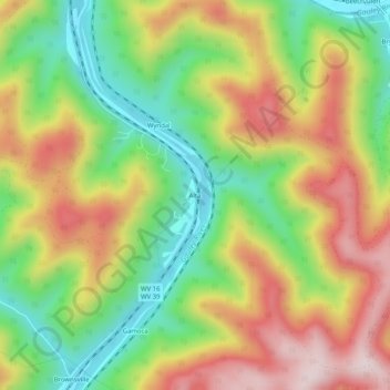
Name: Alta topographic map, elevation, terrain.

Location: Alta, Fayette County, West Virginia, 26690, United States (38.18733 -81.19733 38.22733 -81.15733)

Average elevation: 1,329 ft

Minimum elevation: 627 ft

Maximum elevation: 2,126 ft

Fayette County trails, hiking, mountain biking, running and outdoor activities

Other topographic maps

Click on a map to view its topography, its elevation and its terrain.

Ansted

United States > West Virginia > Fayette County

Average elevation: 1,572 ft

Powellton

United States > West Virginia > Fayette County

Average elevation: 1,552 ft

Smithers

United States > West Virginia > Fayette County

Average elevation: 1,119 ft

Pax

United States > West Virginia > Fayette County

Average elevation: 1,821 ft

Montgomery

United States > West Virginia > Fayette County

Average elevation: 1,106 ft

Gear up for your next adventure:

🥾Men's Hiking Boots - Durable, waterproof footwear for rugged terrain and steep inclines
🔌Solar Panel Charger - Charge gear sustainably outdoors
🪑Portable Camp Table - Compact table for campsite meals
🧣Hiking Neck Gaiter - Multi‑use neck protection for outdoor weather
🍳Camping Cook Set - Complete cookware for outdoor meals

As an Amazon Associate, this site earns from qualifying purchases at no extra cost to you.