
Grimes topographic map
Click on the map to display elevation.
About this map
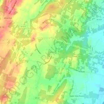
Name: Grimes topographic map, elevation, terrain.
Location: Grimes, Frederick County, Virginia, 22624, United States (39.25816 -78.14611 39.29816 -78.10611)
Average elevation: 761 ft
Minimum elevation: 623 ft
Maximum elevation: 922 ft
Frederick County trails, hiking, mountain biking, running and outdoor activities
Other topographic maps
Click on a map to view its topography, its elevation and its terrain.
Kernstown Battlefield Park
United States > Virginia > Frederick County > Winchester > Valley Acres
Average elevation: 791 ft