
Make a donation
Gear up for your next adventure:
As an Amazon Associate, this site earns from qualifying purchases at no extra cost to you.
Landkreis Merzig-Wadern topographic map
Click on the map to display elevation.
Make a donation
Gear up for your next adventure:
As an Amazon Associate, this site earns from qualifying purchases at no extra cost to you.
About this map
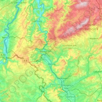
Name: Landkreis Merzig-Wadern topographic map, elevation, terrain.
Location: Landkreis Merzig-Wadern, Sarre, Allemagne (49.37213 6.35760 49.61303 6.96296)
Average elevation: 1,027 ft
Minimum elevation: 430 ft
Maximum elevation: 2,343 ft
Make a donation
Gear up for your next adventure:
As an Amazon Associate, this site earns from qualifying purchases at no extra cost to you.
Other topographic maps
Click on a map to view its topography, its elevation and its terrain.
La Sarre
Allemagne > Sarre > Communauté régionale de Sarrebruck > Sarrebruck
Average elevation: 741 ft
Dorf im Warndt
Allemagne > Sarre > Regionalverband Saarbrücken > Dorf im Warndt
Average elevation: 840 ft
Réhling-Sierbourg
Allemagne > Sarre > Landkreis Saarlouis > Rehlingen-Siersburg > Réhling-Sierbourg
Average elevation: 682 ft