
Thank you for supporting this site ❤️
Make a donation
Make a donation
Gear up for your next adventure:
As an Amazon Associate, this site earns from qualifying purchases at no extra cost to you.
Firvidas topographic map
Click on the map to display elevation.
Thank you for supporting this site ❤️
Make a donation
Make a donation
Gear up for your next adventure:
As an Amazon Associate, this site earns from qualifying purchases at no extra cost to you.
About this map
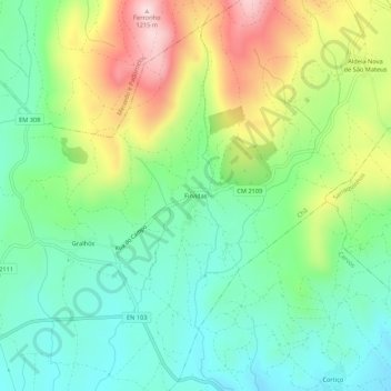
Name: Firvidas topographic map, elevation, terrain.
Location: Firvidas, Chã, Montalegre, Vila Real, 5470-065, Portugal (41.77191 -7.74191 41.81191 -7.70191)
Average elevation: 3,212 ft
Minimum elevation: 2,805 ft
Maximum elevation: 3,967 ft
Thank you for supporting this site ❤️
Make a donation
Make a donation
Gear up for your next adventure:
As an Amazon Associate, this site earns from qualifying purchases at no extra cost to you.